
Portland, Oregon and Helsinki, Finland--(Newsfile Corp. - August 11, 2026) - Geomorphic AI ("Geomorphic" or the "Company"), an AI-driven prospect generator in the minerals exploration sector, is pleased to announce it has more than doubled the land position at its Pora Gold Project ("Pora" or the "Project"), a gold exploration project in the orogenic belt on the Raahe-Ladoga suture zone in Ostrobothnia, Finland.
Geomorphic has filed two new reservation applications covering an additional 10,798 hectares, increasing the total Pora land package to approximately 20,601 hectares, or 206 square kilometres, principally across the Alajärvi, Perho and Vimpeli municipalities. Both were registered on 29 July 2026 and are now on the public mining register. The Project is available for sale or joint venture.
The two new ground applications include the Pora Core District Extensions (4,748 hectares) — which surrounds the Company's original Pora reservation and its Pora North application — and Iiruunjärvi (6,050 hectares), a detached position two kilometres to the southwest. Across the four titles the controlled compilation contains ten source records grading 1.0 to 28.0 g/t Au at eight approximate published-point localities — the 28.0 g/t result, a mineralised glacial boulder found inside the Iiruunjärvi application, its bedrock source not yet located — including a 9.0 g/t Au outcrop that also assayed 1.13% copper and 25 g/t silver. So far, 26 source records at fifteen approximate published-point localities grade at or above 1 g/t Au, and several of the higher-grade results occur near a GTK-mapped regional fault trace; a single continuous mineralised structure has not been demonstrated.
Geomorphic AI VP of Business Development, Jeff Phillips said, "Gold grades occur at surface at Pora, and four of the district's higher-grade in-situ and piece samples lie within 175 metres of the same GTK-mapped regional fault trace. That proximity remains to be tested, and 20.7 kilometres of the fault trace runs through our ground. The highest sample in the reviewed 34,815-site GTK national regional-till Au dataset sits inside our granted reservation. This is a large district that different groups explored at different times between 1967 and 2014 — some of it for gold, much of it for copper, molybdenum and iron. The gold potential here is excellent, and what we have done is tie that scattered record together within one set of exact title boundaries."
PROJECT HIGHLIGHTS
- District doubled to 20,601 hectares: two applications registered on 29 July 2026 add 10,798 hectares of new ground — Pora Core District Extensions (4,748 ha) and Iiruunjärvi (6,050 ha) — alongside the granted Pora reservation (3,564 ha) and the Pora North application (6,240 ha).
- High-grade gold occurs near a mapped regional fault trace: four of the district's higher-grade in-situ and piece surface samples lie within 175 metres of the GTK-mapped Hallapuro fault trace — 9.92 g/t Au at 173 m, 8.8 g/t at 160 m, 6.54 g/t at 83 m and 2.84 g/t at 29 m (distances to the structure, not sample lengths or drill intercepts). The 15.0 g/t boulder find point lies 116 m off it, and 20.66 km of the trace runs inside the district. These distances show proximity, not demonstrated mineralised continuity.
- 9.0 g/t Au from outcrop, with 1.13% Cu and 25 g/t Ag: Outokumpu locality 72 293, in the Iiruunjärvi application, is recorded as paljastuma — in-place bedrock, not glacial float — in mica gneiss with chalcopyrite and arsenopyrite logged. The panel also carries 83 ppm cobalt and 2.8% sulphur.
- 28.0 g/t Au, and its up-ice source-search geometry: Outokumpu sample 67P 975 is a mineralised glacial boulder inside the Iiruunjärvi application — the highest-grade public boulder assay inside the application with an official database coordinate. It sits 2,850 metres at 315° up-ice of the Iiruunjärvi boulder train, within the 310-320° priority ice-transport direction. The district covers 79% of the 290-345° source cone at three kilometres from that train, and 96.8% of the priority cone. The bedrock source has not been located.
- An 18-row boulder report population, arsenopyrite logged on 15 rows: GTK's Iiruunjärvi report tabulates 18 mineralised-boulder rows in a 249 × 490 metre footprint on the lake's south shore; nine grade at or above 1 g/t Au, to 11.2 g/t. On their reported coordinates the population plots 115 to 156 metres immediately outside the application and is not company ground. The 11.2 g/t value is a report-table figure with no certificate in any public layer. The application holds the ground up-ice of them.
- Highest gold-in-till sample in the reviewed GTK national regional dataset: 1,434 ppb Au (sample 70984), ranked first among the 34,084 records with numeric Au values in the reviewed 34,815-record dataset and 1.48× the second-place sample, 554 kilometres away — inside the granted Pora reservation. Within the reviewed GTK national regional-till Au dataset, four sites fall inside the 206 km² district; a further 2,822 GTK till-sample inventory records at approximately 1,779 distinct coordinates are mapped inside the titles, and analyte availability requires confirmation.
- Bedrock gold at Peurakallio, and repeat variability consistent with heterogeneous or potentially coarse gold: GTK sample 19991210 — quartz-altered mica gneiss logged as outcrop in a road ditch, 25 metres from historic hole R1 — returned 9.52 g/t Au. Sample 19961870, a quartz-altered skarn 242 m from the Hallapuro trace, returned 5.2 and 12.8 g/t Au on two determinations of one sample. The 2.5× repeat spread is consistent with heterogeneous or potentially coarse gold but is not diagnostic without dedicated assay or mineralogical work. One Saunasaari arsenopyrite-bearing boulder likewise has two reported determinations, 30 and 33 g/t, although their spread is much smaller.
- A new 3-D reconstruction converts Peurakallio's historic drilling into a structural target: the midpoints of all four published intersections above 2 g/t Au — 5.01, 2.28, 2.26 and 2.14 g/t, in four separate holes — are geometrically compatible with one steep plane. The fit — nine holes at the report's 45° inclination and hole R1 at the collar register's 47.3° — strikes 320.9°, spans 208 metres and has a 0.86 metre root-mean-square residual. The plane is steep to subvertical: the point estimate is 89.8° and the modelled uncertainty range is 73° to 89°. The strike independently matches GTK's mapped 315-330° shears. Downhole composites include 3 m at 1.773 g/t Au from 67 m. Several holes re-read as untested rather than negative: R4 stopped approximately 34 to 44 metres short of the fitted plane across the modelled dip range; R5 was drilled away from it; and R9 began beyond it. The report states that 295 one-metre samples were collected. Its printed assay tables contain 61 selected rows representing 58 unique interval labels; a complete analytical ledger was not recovered. The report states that the core is stored at GTK's Loppi core archive.
- Published ground IP survey footprints cover 3.7% of the district: the 2001-02 high-resolution airborne survey covers 100% of the district. A 0.50 km² dipole-dipole IP block run in June 1991 sits directly over the Suolasalmenneva quartz-arsenopyrite vein inside the granted reservation, where four vein samples returned 7.97, 2.32, 2.05 and 1.43 g/t Au at surface. No public GTK drill-collar record was identified as following that vein.
- Gold-directed drilling totals 995 metres, in one collar cluster: ten holes, all at Peurakallio and all inside a single 457 × 338 metre cluster, are the only identified public gold-directed drilling with collars inside the 206 km² district — a density of 4.83 metres per square kilometre. No public GTK gold-directed drill-collar record was identified in the Peltokangas, Hallapuro-Rahkaneva or Suolasalmenneva corridors or the Iiruunjärvi lake core. Separately, the controlled compilation contains 41 boulder/float source rows inside the titles; 26 carry no quantitative gold value.
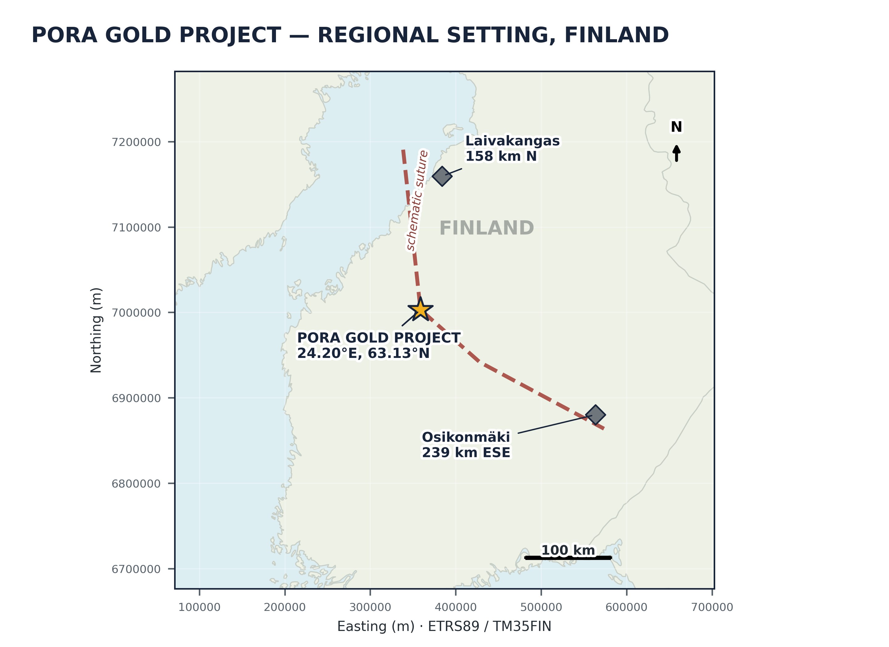
Figure 1: Regional location of the Pora Gold Project in Finland. Distances are GRS80 geodesics from the plotted Pora reference.
To view an enhanced version of this graphic, please visit:
https://images.newsfilecorp.com/files/12557/309199_ac0f04ec34772850_001full.jpg
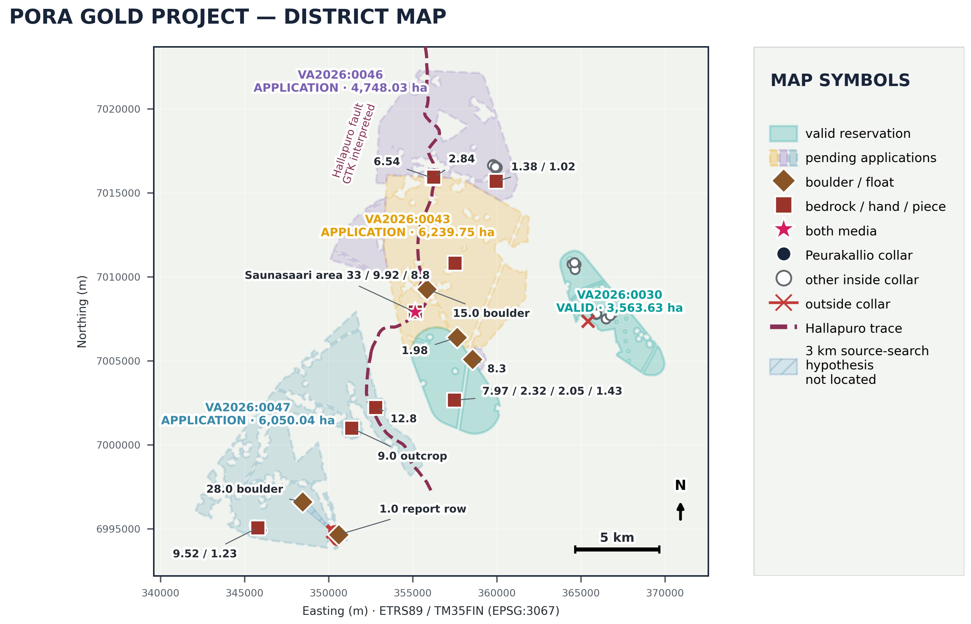
Figure 2: Pora district titles, gold localities and historic drilling. VA2026:0030 is valid; the other three titles are pending applications. The hatched area is an up-ice search hypothesis, not a located source. Saunasaari is plotted at a report-area reference (±300 m) and its 33 g/t is the higher of two determinations on one sample; the 9.92 and 8.8 g/t piece samples share that symbol but are a separate locality. The 1.0 g/t report row is plotted on a corrected coordinate; on its reported coordinate, as stated in the text, it lies outside the application.
To view an enhanced version of this graphic, please visit:
https://images.newsfilecorp.com/files/12557/309199_ac0f04ec34772850_002full.jpg
Why the New Ground Is Prospective
Iiruunjärvi — high-grade surface gold near a mapped regional fault and an unresolved source search. The controlled compilation contains six source records at five approximate localities at or above 1 g/t Au inside the application, headed by the 28.0 g/t boulder and the 9.0 g/t gold-copper-silver outcrop, and contains 7.28 km of the mapped Hallapuro fault trace. The 18-row report population plots 115 to 156 metres immediately outside the application on its reported coordinates and is not company ground; what the application does hold is the ground immediately up-ice of it, and the 28.0 g/t boulder sits 2,850 metres along that 315° vector. GTK's work in the wider Iiruunjärvi-Peurakallio area included three 2009 Iiruunjärvi shoreline mapping holes outside the current application and ten shallow Peurakallio holes drilled inside it in 2013-14. GTK's official 1:20,000 low-altitude aeromagnetic map sheet 233102 reports a map-sheet mean of 51,219.59 nT and shows an inner closed 54,100 nT contour beneath Iiruunjärvi lake, approximately 2,900 nT above that mean. The map confirms a magnetic high but does not identify its cause; GTK reported that no outcrops occur over the anomaly, and the controlled collar register contains no public collar in the application's Iiruunjärvi lake-core area. The public record does not document a located boulder source. The last identified GTK reservation lapsed in 2014; intervening title history has not been fully established.
Pora Core District Extensions — closing the boundary and extending a high-priority geochemical vector in the district. The application adjoins the granted Pora reservation and the Pora North application. It brings inside the block the 8.3 g/t Au sample that fell 40.7 metres outside the granted boundary; it adds approximately 4.63 km of in-application room along the projection of the approximately N15°E Peltokangas mineralised-zone trend, capturing the 2.84 g/t Au quartz-rock outcrop sample near the Peltokangas corridor, whose exact relationship to the reported Peltokangas zones remains unverified; and it secures the paired 1.38 and 1.02 g/t Au sericite-quartz locality to the east. It also adds 5.18 km of the Hallapuro trace and nine historic Outokumpu holes at Vinnolinneva, drilled for molybdenum, copper and tungsten in 1967 and 1980; the public reports reviewed do not show systematic modern low-detection gold coverage.
Joint Venture or Sale
The Pora district offers 20,601 hectares of gold exploration exposure on an orogenic belt, secured and packaged at reservation stage. Geomorphic has compiled and re-verified the historic drilling, surface geochemistry, till, boulder and geophysical record across all four titles against exact registered title geometry, and has defined a low-cost, desk-and-archive-led first programme: recovery of the complete Peurakallio analytical ledger and logs, and investigation of five inside-title MDaE observations marked as chemically analysed but lacking displayed quantitative results; acquisition and reprocessing of the raw 1991 Suolasalmenneva and 1996 Hallaneva induced-polarisation data; selective re-assay of archived till and of historic Vinnolinneva and Pännärinneva core for gold and an As-Sb-Bi-Te-W pathfinder suite; near-field source searching over the 28.0, 15.0 and 8.3 g/t anchors; mapping and sampling of the Hallapuro corridor, the Peltokangas visible-gold zones and the Suolasalmenneva vein; and ground induced polarisation over the structural intersections ahead of any drilling. The Company will consider a joint venture, earn-in or sale; Geomorphic contributes the ground, data and targeting.
For joint-venture and partnership enquiries, please contact:
Jeff Phillips, VP Business Development | investors@geomorphic.ai
About Geomorphic AI
Geomorphic AI is a prospect generator. Using systematic, data-driven screening of geological databases and historic datasets, the Company identifies overlooked mineral systems in Tier-1 jurisdictions, secures the ground, and compiles drill-ready data packages. Geomorphic then advances these projects through joint ventures, earn-in agreements and other partnerships with operating companies that fund and execute exploration, while Geomorphic retains a continuing interest.
Technical Notes
The exploration results referred to in this release are historic in nature and are drawn from the Geological Survey of Finland (GTK), Outokumpu company records and other public sources, including GTK Archive Report 2/2015 (Laxström & Kontoniemi), GTK report M19/2331/99/1/10 (Lindmark, 1999), GTK report M19/2331/87/1/10 (Nikander, 1987), GTK report M19/2331/2010/21, the GTK Kansannäyte and Mineral Deposits and Exploration sample databases, the GTK bedrock drilling-collar register, the GTK geophysical survey-footprint layer, GTK low-altitude aeromagnetic map sheet 233102 (IIRUU; published 2002), the GTK national regional till geochemistry dataset and the live Tukes mining register. The Company has checked the public-source transcription, arithmetic and title geometry described above, but has not independently verified the historic fieldwork or assays. No Qualified Person has undertaken sufficient work to verify the historic information or to classify it as a current Mineral Resource; the Company is not treating it as a current Mineral Resource. No Mineral Resource exists on the Project, none is implied, and no tonnage or grade target is stated or intended. Sample types are distinguished throughout as reported by GTK: lohkare (glacially transported boulder), palanäyte (piece sample) and paljastuma (in-place outcrop). Several of the highest-grade samples reported here — including the 28.0 g/t, 15.0 g/t, 8.3 g/t and 1.98 g/t results — are from glacially transported boulders. They record the grade of transported material; the bedrock sources have not been located, and the find points are not themselves drill targets. Surface, grab, piece and boulder samples are selective by nature and may not be representative of the true grade or width of any mineralised zone. The 12.8 g/t and 5.2 g/t values are two determinations on one sample, not two samples, as are the 30 g/t and 33 g/t Saunasaari values; repeat determinations are reported as such and are never counted as additional samples or averaged. Figure 2's 26-source-record denominator preserves separately cited archive and database rows for auditability; it is not a count of 26 unique physical samples and is collapsed to 15 approximate published-point localities. The Saunasaari boulder's field coordinate has not been recovered from the archive; Figure 2 plots it at the report-area/outcrop reference locality with approximately ±300 m positional uncertainty, not at a recovered boulder find spot. Where an Outokumpu analysis string records an element as 0, that denotes an element not determined rather than a measured zero; no absence of an element is asserted on that basis. Reported drill intercepts are downhole lengths; no downhole surveys were published for these holes, all modelled traces are straight-line projections, and true widths are not known. The Peurakallio three-dimensional reconstruction is a geometric hypothesis fitted to the selected best intervals GTK chose to publish, and is subject to that publication bias; it demonstrates geometric compatibility, not geological identity, and establishes no width, plunge, continuity, tonnage, grade or economic parameter. The reconstruction models nine holes at the report's 45° inclination and hole R1 at the collar register's 47.3°; the fitted plane is steep to subvertical and its dip is not tightly constrained. Gold analyses on the historic Peurakallio core used a 50 g fire-assay charge, which may be insufficient where heterogeneous or coarse gold is present; dedicated screen-fire, metallic-assay or mineralogical work would be required to establish whether that condition exists in the drilled material. Geophysical and magnetic features described here are undrilled targets and are not defined mineralised bodies; the Hallapuro fault is mapped by GTK as interpreted from magnetic data. The 4.63 km Peltokangas figure is the exact length within VA2026:0046 of an N15°E projection through the published zone-corridor midpoint; it is prospective strike room, not demonstrated mineralisation. Up-ice source-cone coverage figures state the proportion of the stated search sector that falls inside the titles; they do not imply that any bedrock source has been located. The live TUKES register lists one valid reservation (VA2026:0030) and three reservation notifications at application status (VA2026:0043, VA2026:0046 and VA2026:0047); TUKES had issued no decision on those three as of 7 August 2026. Under TUKES guidance, a valid reservation or reservation notification may provide priority for preparing an exploration-permit application, but it does not itself authorise exploration operations, land access or mining. Exploration may proceed only through an applicable legal route, such as limited prospecting work, landowner consent or an exploration permit. Areas quoted are the exact areas on the live Tukes register at 6 August 2026. Laivakangas and Osikonmäki, named on Figure 1, are third-party properties shown to orient the Project on the belt; they are not properties of the Company and no result at either is indicative of any result at Pora. Readers are cautioned not to place undue reliance on historical data.
Forward-Looking Statements
This release contains forward-looking statements subject to risks and uncertainties, including the grant, timing and final terms of the pending reservation applications, permit timing, archive and re-assay results, the interpretation of historical, boulder-provenance, geophysical and three-dimensional structural data, the relevance of nearby deposits as analogues, commodity prices, and exploration outcomes. Actual results may differ materially. Readers should not place undue reliance on forward-looking statements, which are made as of the date of this release.
To view the source version of this press release, please visit https://www.newsfilecorp.com/release/309199

/Data%20codes%20through%20eyeglasses%20by%20Kevin%20Ku%20via%20Pexels.jpg)
/Space/Rocket%20launch%20streak%20by%20Alones%20via%20Shutterstock.jpg)